
Updating the intersection at Whitford Brown Avenue is currently planned for the future.
Find out more about what's been completed:
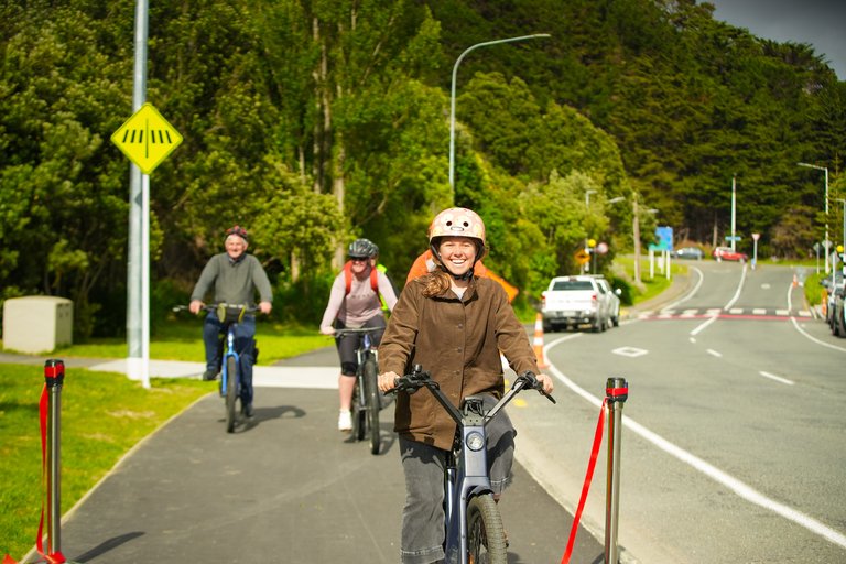
Check out this video for a bird’s eye view of the new shared path and pedestrian crossings on Papakōwhai Road.

A ribbon cutting ceremony marked the completion of the shared pathway constructed along the eastern side of Papakōwhai Rd. The path improves the connection between key locations including Aotea College, Aotea Lagoon, Paremata School, and Paremata Railway Station. Construction began in November 2023 and was completed in October 2024.
The shared pathway also forms part of the Te Araroa Trail and will tie in with a planned upgrade of the Papakōwhai Rd and Whitford Brown Ave intersection currently planned for 2025/2026.
This shared path supports the Council's objectives to reduce emissions and focus on moving towards a more climate-resilient way of life.
A new pump track was installed early December 2023 at Aotea Lagoon as part of the shared pathway project. The pump track is a loop of mounds and curves providing the ultimate riding experience with perfect geometry for rhythm and flow for those on bikes, scooters, roller blades, roller skates and skateboards.
The project was fully funded by the Government’s Transport Choices fund (led by NZ Transport Agency Waka Kotahi).
The Transport Choices fund is about making changes to streets and the way people use them. This is to enable people to take alternative modes of transport for their activities or commute (i.e. embrace walking, cycling or public transport as a means of travel).
View a plan of the shared pathway works
We are on the home stretch to finish this work and expect to be completed within the next couple of weeks. There are just a few minor finishing touches to be made.
Work at the off-ramp/slip lane from Mana Esplanade into SH 58/Paremata Rd:
Romesdale Rd & Brora Cres pedestrian crossing lights:
Replacement of the Police College intersection street light poles:
Pedestrian crossing at the southern Aotea Lagoon car park:
Tweed Rd pedestrian crossing:
Installation of picnic tables and park bench:
Work on the shared path is progressing well and despite the continued wet weather, which has slowed things down a bit, we are still on track to be finished in October.
Closure of off-ramp/slip lane from Mana Esplanade into SH 58/Paremata Rd (10am-3pm)
Between Whitford Brown Ave and Tweed Rd
Brora Cres to the southern railway pedestrian overbridge
Planting on Papakōwhai Road berms
Planting has started on the berms alongside Papakōwhai Road, including near 38 - 42 Papakōwhai Road and the berm below 21 Langwell Place / Bowler's Wharf Lane. The planting will improve the biodiversity in the area and is fully funded as part of the shared path improvement project (which is fully funded by the government).
Work continues to progress well as we near the end of the Papakōwhai shared path project. The wet weather has caused a few delays to road surfacing and line markings, but we are still on track to be finished in October.
Road and lane closure update
Possible closure of off-ramp/slip lane from Mana Esplanade into SH 58/Paremata Rd
Shared path tie-in to Whitford Brown Ave intersection
Please note that the Papakōwhai shared path ends at the raised pedestrian crossing at the southern Aotea Lagoon carpark. The tie-in to widen the rest of the path down towards the Whitford Brown Ave intersection is planned for the Whitford Brown Ave/Papakōwhai Rd intersection improvements project which, subject to funding, is planned for 2025/26.
Project update
Between Whitford Brown Ave and Tweed Rd
Work at the Police College entranced is completed apart from repainting the street light poles to plain ones at the raised table.
At Tweed Rd we will be finishing the landscaping work behind the path this week with line markings on the road to do when we get good/dry weather.
The raised pedestrian crossing at the northern Aotea Lagoon carpark is completed with some topsoiling behind the path to be done. The raised pedestrian crossing at the southern lagoon carpark will be completed early next week along with some final paving on the shared path across from the lagoon.
Brora Cres to the southern railway pedestrian overbridge
Work in this section is completed apart from some topsoiling behind the new shared path and some fencing at the pedestrian overbridge.
Between Whitford Brown Ave and Tweed Rd
The remedial work on the raised table and intersection at the Police College is completed and we will be swapping out the light poles at the raised table with some plain ones once they arrive.
The majority of work at Tweed Rd is completed with just the raised pedestrian crossing and line markings to finish off. We are in the process of submitting the required documentation to finally liven the remainder of the streetlights for the project.
We have poured the new the concrete for the bus shelter pad (where the current bus stop is located) and will be laying some asphalt behind it.
Over the next couple of weeks, we will be completing the raised pedestrian crossings at the northern and southern Aotea Lagoon carparks.
Brora Cres to the southern railway pedestrian overbridge
The watermain replacement, raised pedestrian crossing and construction of the shared path has been completed and the road closure will be removed on Friday 23 August. The road will then be fully open and pedestrians, cyclists and those on scooters will be able to use the new shared path.
We are expecting the street lighting in this area to be back on within the next week or so.
Brora Cres to Paremata Drive road and lane closure update
Due to wet weather, and additional time needed by Wellington Water for the watermain replacement, we are requesting a one-week extension for the road closure until 23 August (TBC):
NB: Pedestrian access will be maintained throughout road and lane closures.
Planned work to close the off-ramp /slip lane from Mana Esplanade into SH 58/Paremata Rd
We are working with the Wellington Transport Alliance on an application to close this off-ramp at the end of August for a couple of weeks. This is the northernmost part of the shared path project and work involves improving pedestrian and cyclist access and safety by installing new kerbs, resurfacing the path and installing bollards to prevent parking in this area.
Once the application is confirmed and the work begins road users will need to access SH58 / Paremata Rd via the SH59 Paremata roundabout.
Between Whitford Brown Ave and Tweed Rd
This week we are finishing the work at the Tweed Rd intersection (concreting the footpath and doing the line markings on the road) as well as the remedial work on the raised table and intersection at the Police College.
We are also installing the last of the streetlights at the Tweed Rd intersection. These will be livened in the next two weeks.
Over the next couple of weeks, we will be installing the kerbing at the northern Aotea Lagoon carpark raised pedestrian crossing and continuing work on the southern carpark raised pedestrian crossing.
We will also be installing a new concrete bus shelter pad where the current bus stop is located. This is part of work to be undertaken by Greater Wellington Regional Council to upgrade the bus stop with a new shelter.
Please note that the new widened shared path officially stops at the raised pedestrian crossing at the southern Aotea Lagoon carpark. The footpath south of the crossing to the Whitford Brown Ave intersection will be improved when the intersection works are undertaken, currently earmarked for 2025/2026 (pending NZTA Waka Kotahi funding support).
From Romesdale Rd to Brora Cres
In conjunction with Paremata School we will be installing more plants outside of Papakōwhai Reserve. We will also be removing the current line road markings to put the new and permanent markings on.
Brora Cres to the southern railway pedestrian overbridge
The full road closure currently remains in place until Friday 23 August. Wellington Water is working in this section to finish the watermain replacement.
Over the next few weeks we will continue demolishing the old footpath, doing the timber edging and preparation for the new path, and completing the raised pedestrian crossing at the overbridge.
Road closure from Brora Cres to Paremata Drive (15 July to mid-August). Access is open for residents only, everyone else to use detours on SH59 or via Brora Cres and Kiriwai Rd. We strongly recommend using the SH59 detour if possible.
Paremata School raised crossing
Line markings and lighting mark the completion of this new raised pedestrian crossing.
Project update
Brora Cres to the southern railway pedestrian overbridge
As mentioned above the full road closure currently remains in place as we work on this section of Papakōwhai Rd. We have been keeping a close eye on the closure now that children are back at school and have noted some delays, particularly at the end of the school day pick-up time. We are modifying signage and continuing to encourage everyone to use the alternative routes.
Key achievements within this section so far include:
Over the next few weeks, we will be doing the timber edging and preparation for the new path, completing drainage and the raised pedestrian crossing at the overbridge.
Progress within other areas of the project
Work between Brora Cres & the southern railway pedestrian overbridge –15 July to mid-September.
Work will include the construction of the shared path, as well as a watermain replacement by Wellington Water. This section of Papakōwhai Rd is extremely narrow so requires a full road closure for most of the work and a lane closure for the rest so we can safely complete this work. Details of the traffic management are:
No parking for vehicles by the southern pedestrian overbridge during this work.
During these closures there will be no on-street parking at the overbridge. Please use the park and ride facility off SH59 or make alternative arrangements.
On-street parking once the work is completed will be moved back approximately 80 metres from the overbridge. This allows enough room for the narrowed road, widened shared path and the raised pedestrian crossing. Moving this parking ensures there is enough width for all users and provides the required visibility to the crossing.
The second set of streetlights along Papakōwhai Rd from Tweed Rd to Brora Cres have now been turned on. This means we now have new lights and poles all the way from near the southern Aotea Lagoon carpark to Brora Cres as well as new lights at the new Paremata School raised pedestrian crossing.
These lights were due for replacement and have been sorted under the Papakōwhai Shared path project.
Paremata School raised crossing
As part of the School Safety programme our shared path contractors have installed a new raised pedestrian crossing at Paremata School. To finish off this week they will be doing line markings, which once completed, will look very effective.
Working in with Wellington Water
We are currently in discussions with Wellington Water about the possibility of incorporating a watermain replacement, north of Brora Cres, into our project works (rather than just repair the leak/s).
The project team would love to accommodate this if we can but if this work goes ahead it may impact our completion date for the shared path but would be a good outcome. We’ll keep you posted.
Project update
Between Whitford Brown Ave and Tweed Rd
We have completed the majority of the path work, installed topsoil and are finishing the last bit of the fence rail on the retaining wall on the Police College side. The majority of traffic cones have been removed from this section and the path is open.
In the next week or so we will be doing some remedial work on the speed humps at the Police College and completing the intersection work.
Raised crossing at southern carpark Aotea Lagoon
We have utilised our current contractor to deliver a pedestrian raised crossing at the Aotea Lagoon southern carpark. Originally a part of the Whitford Brown intersection upgrade project, we have calved off this crossing so it can be delivered now, as the rest of the Whitford Brown project has currently been deferred.
We have altered the exit at the southern carpark to accommodate the raised crossing and in the next week or so we will start drainage work and will also be installing the new kerb, channel and paths.
Between Tweed Rd and Romesdale Rd
We began the drainage work at Tweed Rd, demolished the existing footpath and prepared the new kerb and channel at the Tweed Rd intersection. We also completed the drainage work for the northern Aotea Lagoon carpark pedestrian crossing.
Next, we will be pouring the kerbing, preparing and pouring the path and installing a new light pole on the Lagoon side.
Romesdale Rd to Brora Cres
We’ve completed remedial work on the Romesdale Rd raised crossing and we’ve started landscaping with mulching where the Council and school children have planted. Over the next couple of weeks, we will be doing line markings at the crossing and installing new signs.
We will continue with one lane closed in Brora Cres as we pour the new kerb, channel and path, install a new light pole and do the topsoiling.
Upcoming road closures / traffic management
This is an update on the road closures and traffic management measures in place over the next few months as we work towards completion in October. Our timeframes are indicative and subject to change but here is the current plan:
Streetlights
Just a reminder, the streetlights are out in some sections as we relocate and reconnect light poles along Papakōwhai Rd. We are expecting most of these to be back on within the next two weeks before the lights between Brora Cres and the southern pedestrian rail overbridge are disconnected and then reconnected.
Project update
Between Whitford Brown Ave and Tweed Rd
In the past couple of weeks we have relocated the gas mains, constructed the new kerbing and completed the drainage and ducting at the Police College entrance. We have also installed the new streetlight poles and poured half of the concrete path at this entranceway.
Over the next couple of weeks, the retaining wall at the Police College will be completed the remaining paths will be prepped and paved, we will be turning on the streetlights and completing and reopening the Police College intersection.
Between Tweed Rd and Romesdale Rd
We’ve completed preparations for the shared path which is now ready for asphalt. We have poured the concrete paths, started the paving and laid the raised pedestrian crossing at the Romesdale Rd intersection.
Over the next couple of weeks we will finish the paving, do the topsoiling and grass seeding, and do the line markings on the road.
Romesdale Rd to Brora Cres
In the past fortnight we removed the old streetlights and installed the new ones.
Coming up we will be doing the line markings on the road and topsoiling behind the shared path.
The full 24/7 road closure at the Brora Cres intersection is currently planned for the week of Monday 27 – Friday 31 May. Access will be via the Romesdale Rd intersection or Kiriwai Rd.
Over the next few months there will be several road closures and continued traffic management associated with this work as we move closer to completion. Our timeframes are indicative at this stage but give you an idea of what is coming up:
Streetlights
Just a reminder, the streetlights are out in some sections as we relocate and reconnect light poles along Papakōwhai Rd. This means extended periods of time where some of the lights won’t be operational.
Project update
Between Whitford Brown Ave and Tweed Rd
In the past couple of weeks, we have installed (but not turned on) the new streetlights, asphalted the shared path and started the drainage work required at the Police College intersection.
Over the next couple of weeks, we will be finishing the rest of the asphalting and doing the landscaping. We will also be constructing the raised table at the Police College entranceway and laying the last of the streetlight ducting in this section.
Between Tweed Rd and Romesdale Rd
We’ve continued preparations for the shared path, almost completed the drainage and installed the new streetlights (but not turned on).
Over the next couple of weeks, we will do final preparations for asphalting the shared path and will do the concrete path pour at the Romesdale intersection. We’ll also be topsoiling and grassing behind the new path.
Romesdale Rd to Brora Cres
In the past fortnight we have asphalted the shared path and will now start topsoiling and grass seeding behind the path. Coming up we will also be removing and installing the new streetlights in this section.
Between Whitford Brown Ave and Tweed Rd
In the past couple of weeks, we have completed 95% of the electric cable ducting, we have disconnected and removed the streetlights and installed the new streetlight connection points. We continued preparing the shared path to be ready for surfacing.
In the next fortnight we will relocate the gas mains, the new streetlights will be installed (but not connected up yet) and the shared path will be asphalted.
There will be road closures and stop/go in place at the Police College entranceway so that new drainage can be installed, and the new raised pedestrian crossing can also be installed.
Between Tweed Rd and Romesdale Rd
We’ve continued preparations for the shared path. With this 95% completed, we’ve installed the new tactile pavers and the new kerb line.
The focus over the next couple of weeks is on continuing to install the boxing for the shared path, plus pouring concrete for the path, and laying topsoil and grass seed.
The Brora Cres/Romesdale Rd detours will continue to be in place.
Romesdale Rd to Brora Cres
Over the next fortnight we’re planning to remove the existing streetlights, asphalt the shared path in this section and topsoil and plant grass seed behind the new path.
From Monday 15 April we will be disconnecting some of the light poles along Papakōwhai Rd as part of the new shared path work.
We need to relocate these light poles out of the way of the new path meaning there will be extended periods of time when sections of street lighting will not be operational. The light poles will be reconnected later by specialist contractors.
Between Whitford Brown Ave and Tweed Rd
In the past couple of weeks we have completed the retaining wall outside the Police College entrance and continued preparation work for the shared path.
Next week we begin removing some of the streetlights and installing the new ones. Please note these lights will be reconnected later in the project so will not be operational immediately.
Relocation of the gas pipes will also take place.
Between Tweed Rd and Romesdale Rd
We’ve continued preparations for the shared path; installing the base layer and the new kerb line.
Next week installation of the base layer will continue, and we’ll be constructing the boxing for the shared path.
Romesdale Rd to Brora Cres
Over the next fortnight we’re planning to remove existing streetlights in this section and to install new ones. Again, please note reconnection will happen later in the project so there will be a period of time when these lights are not operational.
Once the light poles are removed, we will asphalt the shared path in this section.
Work is progressing well along three different sections of Papakōwhai Rd.
Between Whitford Brown Ave and Tweed Rd
Stop/go traffic management remains in place while work continues on the retaining wall outside the Police College entrance. The excavated path opposite Aotea Lagoon has been temporarily opened to the public.
Next week excavation and pile drilling will happen at the retaining wall site. We’ll also be relocating underground gas pipes.
Between Tweed Rd and Romesdale Rd
Work has progressed well on the drainage at the Romesdale Rd/Papakowhai Rd intersection meaning that we should be able to partially reopen Romesdale Rd next week. Once this happens southbound traffic on Papakōwhai Rd will be rerouted up Romesdale Rd onto Tweed Rd and back down to Papakōwhai Rd. Papakōwhai Rd will remain open to northbound traffic.
We’ve also been excavating the shared path in this section and have partially installed the base layer. Next week we’ll be completing the path excavations and will continue with the base layer. We’ll also be installing boxing along the path.
Romesdale Rd to Brora Cres
This week we’ve been doing the final preparation for the path including timber boxing. Next week we’ll be asphalting the path and in between the new kerb and the existing road.
From Monday 4 March the Papakōwhai Rd / Romesdale Rd intersection will be closed for up to two weeks until Friday 15 March. (The work is planned to take one week but we have allowed a second week if the weather is poor, or we run into issues.)
This is part of the new Papakōwhai shared path work and relates to the stop/go measures and detours in place on Papakōwhai Rd for the next 6-8 weeks (see the update below from 23 February).
We are closing the intersection so we can do the drainage work and underground service ducting required.
We will be maintaining access to properties at all the times via Tweed Rd. Impacted residents have been advised.
While this road closure is in place:
An electronic signboard advising road users is in place.
From Monday 26 February 2024 there will be various detours and stop/go measures in place for 6-8 weeks along Papakōwhai Rd as we continue work on the new shared path.
Stop/go traffic management
Stop/go traffic management will be in place between Whitford Brown Ave and Tweed Rd from 9am-3pm weekdays. Outside of these hours we will be working off the road and behind the kerb lines so both lanes can remain open. This will help to minimise disruption during peak times.
Detours via Brora Cres/Romesdale Rd for southbound traffic on Papakōwhai Rd.
What to expect:
We will initially trial having the detours in place 24/7 to determine whether this is the least disruptive way of progressing the work. We will continually review this trial over the first week or two to decide whether we should continue with 24/7 detours or limit the detours to 9am-3pm (which would require daily set-up and take-down of the detours and could result in additional time required to complete the project).
Work has progressed well over the past few weeks as we’ve made the most of the summer weather.
Thank you for your patience as we work along Papakōwhai Rd, as well as keeping to the speed limits and following the traffic management instructions, so we can keep our crews safe as they work on the new shared path.
Just to recap: construction work is generally taking place between 7am – 6pm weekdays, with some weekend and night work possible. The project is expected to be completed by the end of this winter.
Between Whitford Brown Ave and Tweed Rd
Work on the section opposite Aotea Lagoon continues as we start on a second retaining wall close to the Police College entrance. We’re currently pulling up the old footpath and preparing the ground for the new shared path. This includes installing ducting for the lighting under the path.
All going well we expect this section of work to be completed by early June 2024.
Romesdale Rd to Brora Cres
We’ve poured the kerb and channel for a large portion of this section and construction of the shared path is starting. We have coordinated with Wellington Water so they could install a wastewater pipe under the intersection alleviating the need for them to come back at a later date and dig up what we’ve done.
All going well we’re hoping to have this section of the work completed by early April 2024.
Tweed Rd to Romesdale Rd
Once work on the two sections currently underway (as above) is completed we are planning to work on the remaining section of the shared path between Tweed Rd and Romesdale Rd.
Traffic management and detours
Just a reminder that as work progresses the layout of the temporary traffic management and detour routes may be subject to change.
Construction on the new Papakōwhai Rd shared path is underway, helping to make it easier to get around this part of Porirua. Traffic management measures and detours are in place to ensure the safety of our workers and of road users.
Construction work will generally take place between 7am – 6pm weekdays, with some weekend and night work possible. This project is expected to be completed by this winter.
What to expect on Papakōwhai Rd:
Other traffic management that may be in place includes:
Where possible please use alternative routes and expect delays.
We now have two active construction sections operating along Papakōwhai Rd as part of the new shared path project.
The first section is opposite Aotea Lagoon and includes work on the retaining wall outside the Police College and construction of the new shared path.
The second section of work on Papakōwhai Rd runs from opposite the bottom of Langwell Pl to just north of Romesdale Rd. This section will include constructing the new shared path and installing a raised zebra crossing at the Romesdale Rd intersection.
Traffic management is in place which will affect road users and roadside parking outside the lagoon. Parking will be reinstated, where possible, after 3pm. The lagoon carparks will remain open at all times.
A detour is also in place to allow for the safety of contractors as they work to widen the path and undertake the other work associated with the project.
Detour / traffic management details:
Expect delays and please consider using alternative routes.
Visit the coffee cart at the southern Aotea Lagoon car park
The coffee cart is up and running in its new location. This is a temporary spot until work is finished – pop in and say hi!
This week
Our contractors are back on site at Papakōwhai Rd and have been marking out the underground services. They are starting work building a retaining wall outside the Police College which will allow us to widen the path along this section.
What’s next…
Work on the shared path will continue opposite Aotea Lagoon for the next few months.
There will be traffic management in place which will affect road users and roadside parking outside the lagoon. Parking will be reinstated, where possible, after 3pm. The lagoon carparks will remain open at all times.
Detours may be in place and there may be occasional weekend work. Expect delays and consider using alternative routes.
Construction work will also be happening in other sections along Papakōwhai Rd and we’ll update you on those as start dates for these are confirmed.
A new spot for the coffee cart
The coffee cart has been temporarily relocated to the southern Aotea Lagoon car park while work is happening in the lagoon area. Don’t worry… they’ll still be serving the same great coffee and operating the usual hours.
So far, we have moved power poles at the northern end of Papakōwhai Rd to allow space for the wider path and have set up the site yard at Papakōwhai Reserve.
We successfully installed the pump track at Aotea Lagoon at the start of December and it is already proving popular with those on bikes, scooters, roller blades, roller skates, skateboards etc.
What’s next…
You won’t see much more happening before Christmas as we wait for our final consents (submitted in August) to come through. Construction work is set to kick off in the new year.
We are still planning to complete the shared path in winter 2024.
Whitford Brown Ave / Papakōwhai Rd intersection
An additional upgrade of the Whitford Brown Ave intersection with Papakōwhai Rd may have to be deferred subject to budget announcements due in late June 2024. You can read more on this below under the Whitford Brown Avenue intersection upgrade heading and timeframe information.
New pump track opens at Aotea Lagoon
An exciting new facility for those that love their wheels has opened in Porirua.
Located at Aotea Lagoon, this new family friendly pump track makes use of the space where the old duck pond used to be.
The pump track is a loop of mounds and curves providing the ultimate riding experience with perfect geometry for rhythm and flow for those on bikes, scooters, roller blades, roller skates and skateboards.
The pump track is 100 per cent funded from the Transport Choices programme administered by Waka Kotahi as part of the Papakōwhai Rd shared path project that’s currently under construction.
The shared path will make it easier to get to and from the pump track on wheels and is just another way of making it more attractive for people to get out of cars and get active.
The pump track has been designed so that it can be moved to other locations around the region in future.
Work on the shared path is due for completion in winter 2024.
Take a look at the media release.
All going well, construction is planned to start 20 November 2023 and be completed in winter 2024.
Work will be done in sections between Aotea Lagoon and the southern pedestrian railway overbridge, mostly on the eastern side of the road where the existing footpath is being widened.
We know Aotea Lagoon is a family favourite and are working hard to minimise disruption.
Work will generally take place Monday to Friday between 7am and 6pm.
Roadside parking will be reinstated, where possible, after 3pm. Both the north and south lagoon carparks will remain open at all times.
It is possible that detours may be in place during some of the work and that there may be occasional weekend work if needed. Road users can expect delays so should consider using alternative routes where possible. Pedestrian and cycle access will remain open.
Read the full community update
Construction of Papakōwhai Road’s shared path will start in late November 2023. The contract has been awarded to John Fillmore Contracting Ltd (JFC) and construction will be done in sections between Aotea Lagoon and the southern pedestrian railway overbridge.
The majority of work will happen on the eastern side of the road where the existing footpath is being widened, where possible, to a 3.5-metre shared path.
Traffic management will be in place and road users can expect delays during construction so should consider using alternative routes where they can. Pedestrian and cycle access will remain open during construction.
A big thank you to everyone who dropped in to our information & feedback session for these projects.
About 60 people attended the evening session at Papakōwhai School on 19 September.
We received a lot of valuable information and comments.
The project was more than just a shared pathway, it was about making a safer, more attractive environment for all. Key features included:
Why was some on-street parking moved?
This was a safety issue. Parking on Papakōwhai Road by the southern pedestrian overbridge to the railway station was moved back approximately 80 metres to allow for narrowing the road, widening the shared path, and the installation of a raised pedestrian crossing. Moving this parking ensures there is enough width for all users, and provides the required visibility to the crossing.
Is it dangerous for children and cyclists to be sharing the same path?
We believe that the path is wide enough for both cyclists and pedestrians to coexist on the path. The previous footpath path was used by pedestrians and cyclists concurrently and was considerably narrower than the new path.
Why didn't you spend this money on fixing the roads?
There are separate budgets for regular maintenance and emergency repairs to the roading network. No money spent on Transport Choices projects is taken from regular maintenance or emergency repair funding. Transport Choices projects are funded by NZTA Waka Kotahi from Government’s Climate Emergency Response Fund, which is resourced via the Emissions Trading Scheme.

A new pump track was installed early December 2023 at Aotea Lagoon as part of the shared pathway project.
The pump track is a loop of mounds and curves providing the ultimate riding experience with perfect geometry for rhythm and flow for those on bikes, scooters, roller blades, roller skates and skateboards.
Intersection improvements and safer crossing points for pedestrians and cyclists are planned for the Whitford Brown Avenue / Papakōwhai Road intersection in the future.
Designs for the work were completed in 2023 however due to the ground conditions, the construction cost exceeded the original budget. The direction of the Government Policy Statement on Land Transport 2024 also resulted in NZTA not approving funding for this project.
In December 2024, Council agreed to defer the $1.41m local share funding for this upgrade to 2026/27.
Why are we doing this work?
As growth continues in this area it is important to provide safe crossing facilities for pedestrians and cyclists using this strategic corridor between Porirua and Paremata. This helps make it easier for people to get around the city without having to always jump in a car – one of the Council’s objectives to help reduce emissions and focus on moving towards a more climate-resilient way of life.
This work will also improve safety for motorists. Current wait times for motorists exiting Papakōwhai Road and turning right across Whitford Brown Avenue can be lengthy. This can lead to frustration and people pulling out when they shouldn’t. Since 2019 there have been 13 crashes on Papakōwhai Road and Whitford Brown Avenue (4 minor and 9 non-injury).
Features of the improvements
The project will include signalised pedestrian crossings, traffic signals, an additional left turning lane out of Papakōwhai Rd and better lighting.
View a draft plan of the improvements
View an overview poster of the intersection improvements
There are already significant delays at Okowai Road at peak times – won’t this make that worse?
We are aware of the current issues on Okowai Road and have completed extensive modelling of the intersection in various scenarios to determine the best intersection option and the resultant effect to level of service and general operation following the intersection upgrade.
During peak school drop-off and pick-up times there will be a decrease in the level of service for Okowai Road during the red phase of the traffic signals for Whitford Brown traffic. The rest of time the modelling shows the level of service on Okowai Road will remain at a similar level.
We do have plans to investigate further improvements to Okowai and adjoining roads in the future to complement the main intersection upgrade. We propose to finalise construction of the new intersection, then monitor the post construction performance and impact to Okowai Road. Then we will be better educated to investigate an appropriate solution for the Okowai Road intersection.
Will the temple construction on Okowai Road cause further traffic issues?
The hearing into the resource consent application for the temple determined that traffic generated would have no more than a minor impact on the existing environment.
To manage the traffic during construction, the resource consent holder will need to supply a Construction Traffic Management Plan (CTMP) prepared by a suitably qualified and experienced person to Council for assessment. The purpose of the CTMP is to set out how the traffic management will be undertaken to remedy or mitigate potential adverse effects from construction traffic.
Why don’t you improve the SH59 intersection?
The SH59 intersection is managed by Waka Kotahi NZ Transport Agency so this is outside of Porirua City Council’s jurisdiction. As part of the Whitford Brown Avenue/ Papakōwhai Road intersection upgrade the new traffic signals will be coordinated with the existing signals on SH59 to minimise disruption.
Why did you choose traffic signals as the preferred option for the intersection?
The traffic signals option makes use of the existing road footprint without the need for any additional land purchase, while still providing improvements for traffic flow and road safety.
A roundabout option was considered but due to land requirements and cost this option was discounted. To install an appropriately sized roundabout a considerable amount of land would need to be purchased from private owners which is not always feasible.
How will the signals work so there are not massive tail backs?
Signals at the new intersection will be controlled via SCATS (Sydney coordinated adaptive traffic system) which allows remote adjustment to signal phasing should any significant delays occur. The proposed signals will be coordinated with the existing signals on SH59 to provide the maximum efficiency.
We are not anticipating a significant reduction in traffic throughput on Whitford Brown Avenue and transit times are not expected to be impacted by more than 40-50 seconds.
Wouldn’t it be better to have a roundabout at this intersection?
A roundabout would require the purchase of a significant amount of land due to the footprint require for an appropriately sized roundabout. This land is currently owned by private entities. In addition, there is potential for similar delays for right turning vehicles from Papakōwhai Road due to the large number of vehicles on Whitford Brown Avenue which is the dominant flow.
In addition:
Why have you chosen to merge two lanes into one where you have? Wouldn’t that be better further up Whitford Brown Avenue by Okowai Street?
We have tested this in our design software and what we have found is that there is insufficient width to allow for two uphill lanes, one downhill lane and a right turn lane while maintaining the minimum required lane widths and maintaining the cycle way up Whitford Brown. To achieve this, we would need to realign the existing kerb and footpath opposite Okowai Road to provide the sufficient width, however this is not achievable within the current project budget.
We would also be required to remove the on-road cycle path to provide the required width, this goes against our project objective to improve the safety of all road users and provide suitable facilities to encourage walking and cycling.
It is also likely that this will would not resolve congestion as a merge from two lanes to one is still required at some point. The current merge location meets the minimum visibility requirements and has been chosen as there is ample forward visibility for road users to perceive the merge. Moving the merging point further up adjacent to Okowai Road introduces significant safety concerns as the merge will conflict with right turning vehicles from Okowai Road.
As part of the project, new markings and signage will be installed to meet current standards. This will provide road users with advanced warning of the upcoming merge which will assist in highlighting the merge point while encourage correct merging practices.
We will monitor the completed intersection performance and if required complete further work, we are committed to getting it right.
If you have any questions? Please email us.
